Miawpukek is the traditional Mi’kmaw name for our community. “Miawpukek” is used as the name of the community in most documents produced by Miawpukek First Nation Government. Documents produced elsewhere most often use “Conne River”. The name means “Middle River”.
Miawpukek became a permanent community sometime around 1822. Before 1822 it was one of many semi-permanent camping sites used by our people who were at the time still nomadic and traveling throughout our Mi’kmaq Domain of Newfoundland, Labrador, Quebec, New Brunswick, Nova Scotia, Prince Edward Island and Maine.
Miawpukek Reserve was established according to traditional oral history in 1870. It was officially designated as Samiajij Miawpukek Indian Reserve under the Indian Act in 1987. Most of our members, as of June 1985, are registered Indians. The ancestries of our community members include Mi’kmaq, Innu, Abenaki and European lines.
Our membership is 822 on-Reserve and 2238 off-Reserve. Our total population on-Reserve as of February, 2022 is 822.
Since being established as a reserve in 1987, Miawpukek has gone from a poor, isolated community with almost 90% unemployment to a strong vibrant community with nearly 100% full-time/part-time employment. We are one of two of the fastest-growing communities in the province of Newfoundland and Labrador. We are often pointed to by Indian and Northern Affairs as a model community for other First Nations.
We are located on the south coast of the island part of the province of Newfoundland and Labrador. By land we are 224 km from the nearest service center, the international airport town of Gander. Our community is accessible by land, air and water.
A visitor coming to our community by land from Gander or any point accessible to the Trans Canada Highway, can travel to our community from the TCH to Route 360, then Route 365.
A visitor coming to our community by air from Gander or any point accessible by aircraft, can travel to our community by wheeled aircraft to St. Alban’s or Float plane to Jipújíj’kuei Kuespem Park (or the local Bay).
A visitor coming to our community by water from any point accessible by watercraft, can travel to our community from the open ocean, through the beautiful Baie d’Espoir fjord and tie up at our new modern shore base finger pier.
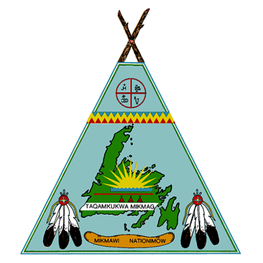
The Great Seal - Taqmkuk Great Seal
The shape of the seal represents both the island of Taqamkuk and the great house of our nation, the regional great council wigwom; the seat of the Taqamkuk Regional Saqamaw representing The Grand Council Government of Migmagee.
The three smaller wigwoml represents our mikmaq brothers residing to the north, west, and east of Miawipugueg.
The arrowed line extending west to east represents the northern border of our mikmaw territory mutually respected and represented by ourselves and our Betaukuog brothers.
The green of the island and the jagged blue, yellow, and red band represents the forests of our land, the sea surrounding our lands, the sun, nagusit, and ourselves, the mikmaw.
The rising sun over the water represents us as members of the wabnagi nation or people of the dawn.
The two triple eagle feather fans represent our respect for the grandfathers and their wisdom as seen from afar.
The canoe represents our connection to travel to and from the island of taqamkuk and other regions in migmagee.
The quartered circular represents niskam, the great spirit, who protects us and migmagee, our land, which sustains us.
Lastly, the virtual severed Avalon region is recent and represents our dispute with Brian Peckford who we set adrift on his own land claim area.